We woke up in the morning, had our breakfast brought from Sabbir’s hotel and initiated our discussion with the immensely helpful caretaker of the Guest House, Mr. Lone. When he heard we had 2 full days of time, he suggested us to visit Tilail valley to Abdullah (Which nowadays are known as Chakwali) village on the first day, till the point civilians are allowed. The road goes further 17 km to reach Kabul Gali and finally runs just by the side of LOC to reach Mushko Valley (famous for Kargil war in 1999) and then finally meets Srinagar – Leh highway at Drass. Gurez is a narrow valley sandwiched by mountains in north and south side where river Kishanganga flows in between from East to West. The valley is one of the best I have ever seen, narrow yet very fertile, having lots of villages alongside the river, you would see farming activities all across, mainly they are into potato farming, potato of Gurez is very famous. The valley gets narrowed initially after Dawar towards the east and then again starts widening from Barnoi Village, which is considered as the beginning of Tilail Valley.
Kishanganga at Dawar:

Wild Flowers enroute:

Barnoi village, start of Tulail Valley:

The Amazing Valley continues:


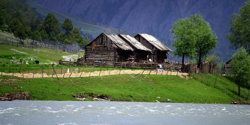
Potato farming in Gurez:

Kishanganga River and Tulail Valley:


It goes on through Barnoi, Dangithal, Tulail, Jurniyal, Manzgund, Badugum, Baduaub to finally Chakwali and then valley again narrows down and the road goes up to the Kabul Gali to cross a mountain pass to reach Mushko Valley on another side. We started our journey and kept going keeping river Kishanganga beside us. The picturesque valley was difficult to describe in words, the interesting part was we were invited almost in every village en route for a cup of tea and roti. We assured all of them we would be back while returning, kept going ahead. It was almost 2.5 hours drive to cover 55 km from Dawar as the road was not in a good shape.
Tulail Valley at its best:


Farming activities at full swing:


We reached Chakwali and crossed the village and kept going ahead, we didn’t see any police or army check post and our idea was to drive until we were stopped by someone.
Chakwali Village and locals:


After another 7km drive we came across a bridge where BEACON labourers were working and we found the bridge was not opened, though there was another road to cross the river through river bed, it was not possible for a low GC car like Innova, though Army convoys could easily cross that and move towards Kabul Gali. We could see from that point, road started ascending again towards hill top and we were told in another 3km there would be an army post where the permits would be checked and as of now no civilian (except army convoy and VIP like MP/MLA/DC) is allowed in that road to Drass beyond that check post. So we took a stop there and cajoled the BRO workers to get a cup of tea but it didn’t happen as they were working in the site and they told they had nothing there to prepare tea. The place was looking amazing, all snow peaks around, the valley half turned into golden yellow due to fall colors, half still in green, looking amazingly gorgeous in the backdrop of clouded sky.
Awesome mountain sceneries as we approaching the end of Tulail Valley:


Gurez is really very scenic place and more beautiful are the people there. While coming back we stopped in Chakwali village for a while and started a small chat with the locals. They were telling us how indifferent Govt/ administrations were for their causes. They got alienated from rest of the world for more than 6 months due to pass closure and Govt couldn’t even provide a simple medical facility there. Any medical emergency usually be attended by Army Doctors and any emergency evacuation even done using army choppers. They have couple of primary and middle schools and one high school in all these 12 to 15 villages across 55km but all of them were mostly built and managed by Army. This was a place where people were really appreciating the work of army for local development. But they have some grudges too, not entirely unreasonable, I have seen myself, the LOC fencing whatever they have put, was atleast 5km inside the actual LOC and unfortunately gone through the middle of the farm land even after the disagreements of the locals. They were telling how these fencing in middle of land and village used to create trouble for them, every day, be it by reducing the farming area, cutting down the short walks across the village, even the cattle get themselves trapped and hurt while grazing through those fences. While chatting, we didn’t even realize when they arranged for namkeen chay and makai ka roti for us. It was really fun to have those with them enjoying the chill outside. That day probably we had 20 cups of tea on the way back to Dawar at different villages. They had to walk 10km for buying biscuits from nearest grocery but they won’t hesitate to offer those biscuits to the complete strangers like us.
The road approaching towards Kabul Gali:

The Bridge upto which civilians are allowed in Gurez – Drass Road:


Warm people of Chakwali Village:


Notice the valley at the far side, a walk of 2 days through that would take you to Sonmarg:

We finally reached Dawar around 6.00pm and watched TV for sometime. Dawar was most important and biggest town of Gurez and it is powered by generator between 6.30pm to 12.00 midnight and again between 5.00am to 6.00am in morning mainly for water heating. Dawar JK Tourism GH was inaugurated last year, located in a fabulous place beside river Kishanganga with Habba Khatun at backdrop. We had our dinner and retired for the day with a plan of exploring the Bagtore side on next day.
Habba Khatun Peak:

Amazing location of JK Tourism GH at Gurez: